- News
- Subscribe
Get full access to Boating Business content
Including the digital magazine, full news archive, podcasts, webinars and articles on innovations and current trends in the leisure marine industry.
- Expert analysis and comment
- Unlimited access to in-depth articles and premium content
- Full access to all our online archive
Alternatively REGISTER for website access and sign up for email alerts
- Industry Database
TZ iBoat launches new map function
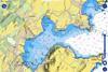
The latest version of the TZ iBoat app includes a new map function combining hydrographic data with high-resolution imagery
Timezero’s marine app, TZ iBoat, now includes a new nautical map features combining several types of data.
vailable for Android and iOS, version 3 of the app brings together raster and vector data, detailed land information, high-resolution satellite images and bathymetric data.
This is premium content
Already a member? SIGN IN now

Sign up for FREE to continue reading!
Want to read more before deciding on a subscription? It only takes a minute to sign up for a free account and you’ll get to enjoy:
- Weekly newsletters providing valuable news and information on the leisure marine sector
- Full access to our news archive
- Live and archived webinars, podcasts and videos
- Articles on innovations and current trends in the leisure marine industry
- Our extensive archive of data, research and intelligence
Get more free content sign up today
Ready to subscribe? Choose from one of our subscription packages for unlimited access!